|
|
|
Advertisements:
GeographyLocation
Western Europe, island in the Irish Sea, between Great Britain and Ireland Geographic coordinates
54 15 N, 4 30 W
Map references
Europe
Area World Ranking: 194
Total 572 sq km
Land 572 sq km Water 0 sq km Area - comparative
Slightly more than three times the size of Washington, DC Land boundaries
0 km
Coastline
160 km
Maritime claims
Territorial sea 12 nm
Exclusive fishing zone 12 nm Climate
Temperate; cool summers and mild winters; overcast about a third of the time Terrain
Hills in north and south bisected by central valley Elevation extremes
Lowest point Irish Sea 0 m
Highest point Snaefell 621 m Natural resources
None
Land use
Arable land 10%
Permanent crops 0% Other 90% (permanent pastures, forests, mountain, and heathland) (2002) Irrigated land
0 sq km
Natural hazards
NA
Environment - current issues
Waste disposal (both household and industrial); transboundary air pollution Geography - note
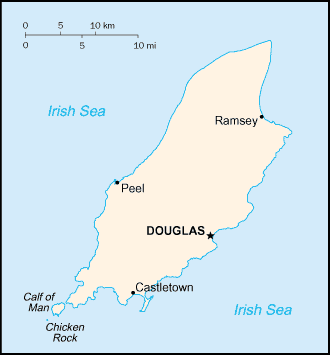
One small islet, the Calf of Man, lies to the southwest and is a bird sanctuary
Comments
Add a new comment: |
Advertisement
Members area
Isle Of Man [ United Kingdom ] (British Crown Dependency):
GPS points from Isle Of Man [ United Kingdom ] (British Crown Dependency)
|
||||||||
 Part of the Norwegian Kingdom of the Hebrides until the 13th century when it was ceded to Scotland, the isle came under the British crown in 1765. Current concerns include reviving the almost extinct Manx Gaelic language. Isle of Man is a British crown dependency but is not part of the UK or of the European Union. However, the UK Government remains constitutionally responsible for its defense and international representation.